


My hat, my face, my stylish shirt.
Two states that prop my hat.
A whispering state, a pack of books.
Say "Cheese!" A honking pat.
A puppy and a mitten,
With a cozy sleeve below.
My drinking cup's the final state.
Learning the names and locations of all fifty states is no easy task, even for older students, but is one of the main building blocks of elementary geography education. Most children recognize a few states - perhaps the states they live in and the ones around it and one or two others - but memorizing all fifty of them and where exactly they are on the map is quite something else. The Northeastern states are all a jumble as are the ones to the west of Illinois and south of Virginia.
Enter Andrew Martonyi's The Little Man in the Map, the winner of the silver Moonbeam Children's Book Award in the Non-fiction picture book category. It is a gem of a resource for parents and teachers on a quest to make US geography engrossing and captivating for young children.
With the help of an imaginary "Man Inside the Map" (the shape formed by five states down the middle of the United States - Minnesota, Iowa, Missouri, Arkansas and Louisiana), Martonyi employs mnemonics, simple verse and a healthy dose of creativity to help spark enthusiasm and excitement for an arguably dry subject.
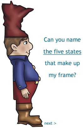
Minnesota is the little man's hat, Louisiana is his boot and Kansas is his backpack. The narrative bestows each state with a function in relation to the ones around it, so if you recognize one, identifying the adjacent ones is a breeze.
To help children assimilate the information in small, bite-size chunks, Martonyi breaks down the US map into discrete regions - Midwest, Southeast, Southwest, Northeast and West.
By the time the story of all the fifty states is told, Ed Olson's graphic illustrations and Martonyi's knack for spotting everyday things in the shapes of the various states have done the trick. The name of each state is recalled with ease. I should know - my seven year-old learnt the entire map in two readings of the book.
Every so often there's a study that bemoans the falling standards of geography literacy. Books like Martonyi's, written for children with an intimate understanding of what captivates and retains their attention, are much-needed agents of change. I wonder if he has plans to tackle world geography next.
Image courtesy: Schoolside Press
2 comments:
How cute... I couldn't guess all of them though. Great gimmick for the young.
nice!
Post a Comment